HISTORIC MAPS OF MALÉ
The MAHS and Maldives National Center for Cultural Heritage are proud to announce the online publication of six historical maps of Malé, the capital island of the Maldives. These come from the collection of the Maldives National Museum, which has generously granted permission for their online publication. Recently, a new set of detailed photographs of these maps was taken and digitally stitched by Aishath Shifa Shafeeg and Hamzah Hassan to produce high-quality digital images of these rarely seen documents. The MAHS is now processing these photographs for our online IIIF Universal Viewer interface to facilitate Deep Zoom navigable interaction with the maps, which will be made open-access available through the Manuscript Viewer on the MAHS website.
Today marks the centenary anniversary of the oldest of these maps, and we take this occasion to present it in a new online collection together with five other historical maps of the capital island of this Indian Ocean nation.
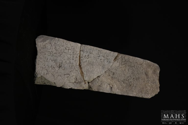
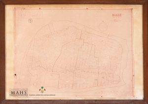
The first map in our collection was completed at Malé on 15 Shawwal, 1339 H. (22 June, 1921), during the 19th year of the second reign of Sultan Muhammad Shams al-Din III (1921). The survey and drawing work were done by Dhon Thuthu (Ibrahim Maafaiy Thakurufaanu) and Bodufulhagge Ibrahim Maniku. They were assisted by Kuda Thuthu and Ahmed Maniku. The Hijri date for completion of the map is written in an original notation at the top left, and a later note added to that presents a converted Common Era date for that (though with what appears to be a conversion error). A separated small note pinned at the bottom right states that this is the original map which H.C.P. Bell translated into English in 1922. This note also mentions that this is the oldest map of Malé to date and that it was 67 years old. This added note was thus apparently written in 1988.
At the top right is a block of text written in a combination of Arabic and an older form of Thaana-script Dhivehi. In addition to providing a Hijri calendar date for the map, it mentions five names, including that of the reigning Sultan (Shams al-Din III). It also identifies Dhon Thuthu, son of Dhon Maniku son of Kalhu Ali Maniku as Head of the commission that produced this map, noting also that he (or possibly his father) bore the prestigious official title of Faamuladheyri, fifth of the six Senior Ministers of the Sultan. It also names others involved with the production of this map: Project Leader Bodufulhaggey Ibrahim Maniku, Kuda Thuthu (son of Sikkagey Moosa Maniku), and Ahmed Maniku (son of Bodufulhaggey Ibrahim Maniku). It is likely that the original map was glued and framed onto plywood backing in 1988.
The distinct lines and features of this map appear to have been written with a traditional Maldivian ink. The amount of detail recorded is impressive, and includes a number of three-dimensional sketches of prominent features including fortifications, bathing tanks, mosques and tombs (ziyaarai), including the flag poles that were customarily erected at such sites. It also provides a site plan of the former palace compound with the number and layout of each building and gate, as well as the surrounding moat, clearly indicated. This map also provides a key defining six distinct conventions for indicating specific building materials used on structures such as thatch, masonry walls, metal or tile roofing, as well as for differentiating wells and bathing tanks (veyo). This allows for a glimpse into the materiality of the built heritage of the capital as it was under the last decades of the sultanate. It also records the original location of various structures that are no longer extant, including the Lonu Ziyaarat and the tomb of Alirasgefaanu (Sultan Ali VI). Around the shore of the island, the map also provides richly detailed depictions of the reef, harbor, jetties, and anchorages, complete with drawings of traditional Maldivian sail craft (dhoni). Kuda Malé, an islet formerly just off the coast in southwest lagoon, is also visible.
The second map in this set was produced soon after the first – during the 21st year of the second reign of Sultan Muhammad Shams al-Din III. Work on this map was led by Dhon Thuthu and Bodufulhaggey Ibrahim Maniku, assisted by Hassan Maniku, Dhon Thuthu and Mohamed Maniku. There is a note on the top right that gives the original Hijri date on which the map was completed. There are two other notes that were added later in 1988: one pinned at the top left with converted CE dates, and another at the bottom right with other details.
It appears that this map was based upon the 1921 map. The lines on this map are faded, and not as clear as the original that it was based on. Although it appears that some of the main features were traced from the earlier map, the detailed treatment and three-dimensional depictions that the former gives to particular buildings and other features is absent here.
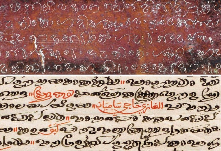
This two-dimensional copy of the 1921 map appears to have been done specifically to accommodate a request by H.C.P. Bell for materials to use in his landmark study of the Maldives. This is corroborated by the fact that the north orientation arrow on this map is identical to that on the map published by Bell, while both are different from that on the original 1921 map. There is an original note on top center of this map clarifying the scale written out long-hand in Dhivehi, rather than numerically, stating that ‘this map is drawn to 1:80 inches’. Bell’s map likewise notes that his map was based on an original map prepared by the Maldive Government and drawn at the same scale of 1:80 inches. The dimensions of this map are identical to Bell’s, and there are a number of very specific details that match up as well, including a note labeling the deep area between two jetties on the central south coast of Malé as ‘Fungandu’.
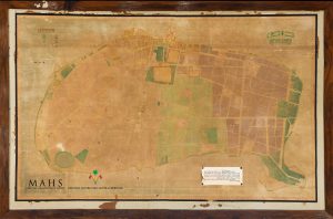
A new colored map of the capital island was produced in 1950. It was commissioned by Mohamed Amin Didi shortly before he became President. The map was produced under Abdullah Ismail (Ismail Kaleyfaanuge Thuthu) under the supervision of Adam Nasseer Maniku, and with the assistance of Maalimee Mohamed Hassan Maniku and Abdullah Ali (Alifulhu Dhon Thuthu). This is the oldest color-coded map of Malé, with demarcations for each ward of the capital city island, as well as for 18 distinct types of features including mosques, ziyaarai, boat houses, city walls and cemeteries, as well as beaches, grassy areas, large trees, and playgrounds clearly indicated.
The Athireegey Thaana typeface that was newly developed at that time is used for the main title. ‘Malé Dhivehi Raajje’ and for the word ‘Thalhudhan’di’ (key/ legend). The Athireegey Thaana typeface was designed by the same Abdullah Ismail of Himithi in Faafu Atoll, who worked on this map. He is known as a famous mathematician who identified an error in Norie’s Nautical Tables, as well as for his spontaneous humor.
This map is oriented with north at the top. It is drawn in imperial scale, and there is a numbered scale ruler grid beginning from right margin and running clockwise. Although the tomb of Alirasgefaanu on the western lagoon is shown, Kuda Malé – which was in previous two maps – is not. The original Hijri date is written on the map under the legend, with the converted CE date added later below that.
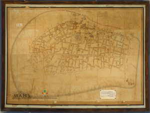
In 1978, a new map was prepared by the Land Registration Division. The title of this map is printed in English at top right, with date and office in which the map was prepared below. Block numbers are given for the first time on this map. Both imperial and metric scale bars are shown at the bottom right of the original map. It is oriented with north at the top.
A legend, which was added later at the top left, is also written in English. Below this legend is a stamp of Malé Municipality. The legend is clearly a later addition as it provides a key to an outline drawn on this map, which is of much later date. This map indicates the changing city limits of three historical moments: 1950, 1978 and1986. The outline of the city in subsequent years are drawn over the map of 1978, allowing us to trace the changing contours of the city over the middle decades of the twentieth century. New blocks are marked on newly reclaimed land added in the areas of the northwest harbor, as well as along the western and southern extensions of the old city limits.
The 1986 map of Malé was produced by pasting together multiple tiles of A3-sized paper. It is much faded, with a faint note at the top left, which begins with ‘Boundary of 1370 H.’ (1950), apparently referring to the 1950 map discussed above. Part of this note, when enhanced, reads that this is prepared by the Land Registration Division of the Ministry of Home Affairs. There is a stamp of Malé Municipality at the bottom of this faint note, which is exactly similar to the stamp on Map 4 of 1978. In the same note, a date of 19 July is legible as are the first three digits of the year: 198… It is likely that this is the map that is mentioned in the note added to the 1978 map, where the complete date is legible: 19 July 1986.
This map provides block numbers. The title is in modern bold Thaana with a decorative floral artwork around the title. All the road names are written in modern Thaana script, as are the names of houses. In general, though, the level of detail depicted remains at blocks, rather than individual house lots. This map is oriented with north at top, but without an arrow specifically indicating that.
The last map in this collection is undated, but it’s relative chronology can be gauged by considering its visualization of land reclamation carried out in the 80’s and later. It is hand drawn, with four wards of Malé color-coded, and all block numbers indicated. The names of most major roads are written in modern Thaana, though some are partially in the Arabic script.
Some newly added blocks on reclaimed land are shown, but the reclaimed areas and blocks of south Malé are not included. The last road on west is Kan’baAisa Rani Hingun, with the subsequent land reclamation on that shore not yet indicated, and the last road on south is Buruze Magu. Hence this map must have been completed before Ameenee Magu was built on reclaimed land, which helps to establish a likely date in the 1980s.