

As the Maldives Heritage Survey (MHS) team has been conducting its survey of heritage sites in Addu/Seenu over the past two months (July-August 2019), we have been struck by the dramatic evidence we are encountering in the field of accelerated erosion of several islands in this southernmost Atoll of the Maldives. On the uninhabited island of Kandiheragandu, a former wetland that was by local reports flourishing there less than a decade ago has now been completely destroyed.
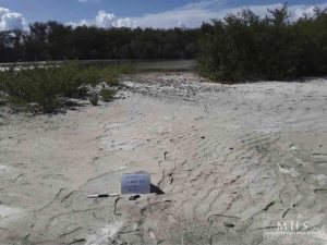
Devastated area of a former wetland on Kandiheragandu (Seenu)
One section of the former wetland area is now simply an expanse of dry sand, while another is freshly inundated with seawater at each tide where only a few surviving mangrove trees remain to demarcate the edge of the island on the southeast.
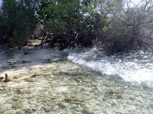
Waves coursing through the last thin line of mangrove on the edge of Kandiheragandu
The shifting currents in the area that seem to have contributed to the destruction of the wetland on one part of the island may have also contributed to the accumulation of a ridge of coral rubble above the waterline that now forms a dry land bridge connecting Kandihergandu with the smaller, formerly separate island of Kodadiheragandu (also known locally as ‘Kudhukandihera’) to the southwest. These
two islands were separate and distinct until quite recently, and appear as such in the Official Atlas of the Maldives published by the Ministry of Planning and National Development in 2008 (although it must be noted that on their maps the name of Kandiheragandu is mistakenly transposed with that of another nearby island, Fathikedeheragandu).
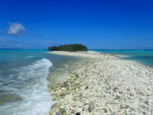
Emergent coral rubble ridge now connecting Kandihergandu and Kodadiheragandu
The MHS team traced the current contours of the coast of this new combined island with GPS tracking to establish a new baseline map that can be used to measure future changes to its shape and size.
Coastal erosion is also clearly now an imminent threat to the largest and most historically significant heritage site in Addu Atoll. The Koagannu Cemetery on Hulhumeedhoo. This remarkable site contains four mosques, a stand-alone minaret, several shrines and over 1,500 ornamented coral gravestones.
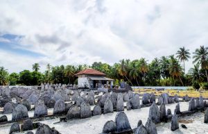
The Koagannu Cemetery on Hulhumeedhoo
On 29 August 2019, strong seasonal waves compounded with a storm surge scoured the north coast of that island, eroding the edge of a community beach park just across the road from this major national heritage site.
Newly eroded coastline nearby the Koagannu Cemetery site
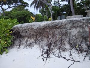
Earlier measures taken there over recent years to protect against such erosion are proving to no longer be effective, as this recent storm washed away huge amounts of sand, exposing and destabilizing the jumbo sand bags that had been previously installed along the beachline.
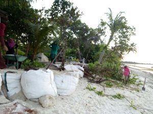
Installation of earlier measures to impede erosion in Hulhumeedhoo
While the local community Hulhumeedhoo has been actively trying to monitor the situation and to mitigate the damage to some extent, the dire situation is clearly beyond the capacity of a single island’s population to satisfactorily address. As is the case in many places in the Maldives, these local crises both reflect symptoms of national and global crises, and require action at these higher levels in response. For
all of us, they provide further evidence for the urgent situation that our environment and our heritage must confront in the face of accelerating climate change.
R. Michael Feener
Project Leader, Maldives Heritage Survey
02 September 2019